Royal Canadian Geographical Society inducts Paul Brett
Paul Brett’s explorations of the world’s seven continents as an educator, program developer, and volunteer is just part of what has earned him the new title of Fellow of the Royal Canadian Geographical Society.
In November, Mr. Brett, Head (Interim), School of Ocean Technology was inducted into the Society’s College of Fellows.
“I’ve spent my career studying and teaching geography and most recently the geography of the oceans and have worked to pass along my experiences to others,” said Mr. Brett. “It’s an amazing feeling that the Society, who embodies my passion for geography, has accepted me into this illustrious circle.”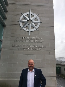
Historic Society
Mr. Brett was one of three Newfoundlanders and Labradorians, along with Ms. Leslie Gratton and Dr. Andrew Bresnahan, welcomed this year as a Fellow along with 88 individuals from Canada, the U.S., Ireland and the United Kingdom.
“The College of Fellows is such a diverse group of people and it reads like a Who’s Who of Canada.”
The first Fellows were named in 1929 and includesNobel Prize-winner Frederick G. Banting, the co-discoverer of insulin, Arctic explorer Sgt. Henry Larsen, and current honorary president, television celebrity and philanthropist, Alex Trebek.
“As a group, we are responsible for expanding geographical knowledge and literacy across Canada and raising the Society’s profile of its educational, research and expeditions programs,” explained Mr. Brett. “That’s a task I take seriously and one I’ve tried to embrace throughout my academic career.”
The Society’s mandate is to make Canada better known to Canadians and to the world. While best known for its iconic publication, Canadian Geographic magazine, the Society supports Canadian geographical expeditions, provides grants and scholarships for cutting-edge geographical research, and is active in supporting geographic education throughout the country.
World Explorer
Mr. Brett’s extensive academic background has been critical to instilling his passion for geography. A MUN alumnus, he holds a Master of Science (Geography) and Bachelor degrees in Education (Post-Secondary), Physics and Geography.
Over his 20 year career, he’s become a specialist in Geographic Information Systems (GIS) and remote sensing but his experience also extends to synthetic aperture radar (SAR), multi-spectral imaging, multi-beam sonar and side scan sonar.
He’s taken that experience to sea as a participant in several ocean mapping-focused research partnerships. From 2008 to 2010, he took part on scientific expeditions with the University of Rhode Island on the research vessel Endeavor, withthe University of Limerick and the Irish Marine Institute on the MV Celtic Explorer and on the Nautilus with the Institute for Exploration, all with the primary mandate of ocean exploration, discovery and education.
“He’s one of the few people I know who has visited all of the continents and worked on and under our oceans, helping to expand our understanding of our planet,” said Glenn Blackwood, VP, Memorial University (Marine Institute) who was named a Fellow four years ago and is currently a Governor of the Royal Canadian Geographical Society.
It is Paul’s passion for geography and his experience working in both the Arctic and the Antarctic that stands out for Blackwood. “Mr. Brett is one of architects of a Coastal Resource Inventory for Nunavut, a project that involved gathering stories and recollections of a changing Arctic environment from Indigenous peoples and preserving the data in a geographic information system.”
At the other end of earth, Mr. Brett travelled with Students on Ice to the Antarctic as a volunteer instructor, delivering geography lectures to students onboard the expedition and as part of the expedition brought students together from Colorado and Mumbai via distance education, this project culminated with lectures atop a glacier in Antarctic and exams while crossing the Southern Ocean.
Inspiring Youth
“There is a wealth of opportunity for this generation and beyond to explore our oceans as a career, there is so much to do as we have spent hundreds of years mapping the landmasses of the earth, we have so much more to do to chart our submerged lands,” stressed Mr. Brett.
For the past several years, Mr. Brett has been a mentor for Memorial University’s Eastern Edge Robotics team and lead organizer for the MATE (Marine Advanced Technology Education) Regional Remotely Operator Vehicle competition for provincial high schools.
“I want to nurture our youth to become explorers of our oceans through ocean technologies like mapping and underwater vehicles.”
He is currently working with alumni members of the Eastern Edge team who have developed an autonomous surface vehicle to map freshwater lakes around Newfoundland and Labrador.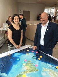
Map Maker
His next project also reaches into the classroom. He’s working with the Royal Canadian Geographical Society and other Fellows from this province to create a giant floor map of Newfoundland and Labrador, which will include the submerged lands of the region such as the Grand Banks.
The heavy-stock vinyl map, roughly half the size of a school’s gymnasium, will allow Kindergarten to Grade 12 students to understand the geographic, economic and environmental importance of the area.
The floor map will come with additional supplies to further enhance students’ experience including map legends, activity cards, props and a teacher guide with curriculum-linked activities to help bring the map to life.
“It’s an exciting project to work on and I can’t wait to see it come together.”